
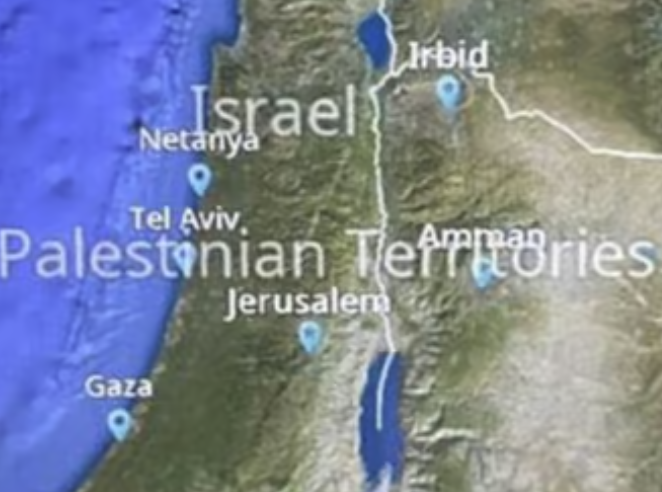
JetBlue’s seat back entertainment map now calls much of Israel “Palestinian Territories. It does so in “significantly larger text” than Israel “to the point where it is overlaid on the entire state of Israel.”
This follows an incident where police were called on a passenger who expressed himself about the Hamas massacre of Israel on October 7th, in response to a flight attendant wearing a Palestine pin. The crewmember used her position of power to crack down on customer speech.
The airline has apologized and is ditching the map provider.
We’re sorry for the concern this has caused. We can assure you that no one on the JetBlue team was involved with drawing or labeling the map of the region and we were not previously aware of the issue.
After a careful review, we have decided to switch to a new map vendor. While our content provider works on making this transition, we have also asked the current vendor to adjust our onboard map so that it aligns with the U.S. government’s map guidance for the region. We are making these changes as quickly as the technology allows.
It took several days, but this seems like a very reasonable response.

One thing JetBlue can’t afford right now is to lose more customers…LOL
Also – the map notations are somewhat amusing since if one insists on using the Latin term of “Palestina” for any part of that region (in English: Palestine, in Arabic: Falastin etc.), then one should indeed include what is today “Jordan” (ruled by the Hashemite family – originating from the Hejaz in today’s Saudi).
The mob screaming “from the river to the sea” doesn’t even know that the area of “Palestina” always included part of the east-to-the-Jordan-river territory. Ever since it was renamed “Provincia Syria Palestina” by the Romans, and then carved up to “Palestina Prima”, “Palestina Secunda” etc. by the succeeding Byzantines.
There is no region in the world treated with such a suspension of reality. Many maps refuse to recognize Jerusalem as Israel’s capital and use their old capital of Tel Aviv which hasn’t been accurate in 50 years and many countries around the world recognize a country of “Palestine” that doesn’t and has never existed – mostly based upon animosity to Jews that doesn’t much exist where Jet Blue is based in the USA. Seems quite reasonable as both a commercial and political issue for an airline based in the second largest Jewish population in the world to be sensitive to their customers on this matter.
Looks like someone simply overlaid words on the map. Probably a rogue employee, not company policy.
And what about the flight attendant? What is JetBlue doing about that?
Go Jet Blue!
They are 2 for 2!
What would Jesus say about this?
Jesus was Jewish and he was NOT ever in politics. Do not forget all the stuff is based on what some old men say happened years before they were born. Today we label them bipolar and but them in mental wards
Uh, the picture you have has Israel and Palestinian Territories in the same size font, like they are worthy of equal recognition or something. I suppose you would prefer it if the Palestinian Territories were subjugated to Israel?
Remember modern day Nazi ideology sadly still exist everywhere…..
@Farnorthtrader Yes, in the same reason that we don’t put “Disney World” the same size font as Florida or the United States, because it isn’t equal to a state or nation. The Palestinian Territory is was formerly annexed as a part of Jordan, and now defined by International Treaty called the Oslo Accords. It’s not an independent country but broken up into 3 separate zones, one controlled by Israel, one controlled by Israel and subject to further negotiations, and the last which includes Gaza intended to be controlled by the Palestinian Authority – but clearly Hamas is in control of most of it in reality (until the current war which has removed them from much of the area).
Clickbait
Jesus would ask ‘What’s a Palestinian?’
@Joe … +1 . Perceptive .
@JetBlue … Save your phony excuses for the gullible wokists at NYT . We see your schtick .
@Alert…and @Gary
WHAT should JetBlue have done different.. they fired the company that handles the maps.
Initial response may have been slow..but fair enough….Companies have to move swiftly but carefully. They had to figure out exactly what happened.
I know Gary is a JetBue hater…probably an ex B6 employee who got fired or something but all of his anti Jetblue stuff is pathetic.
How is ‘Palestinian Territories’ in ‘significantly larger text’ than ‘Israel’ in that image? They appear to be in the same font size, but Israel is a shorter name so it takes up less space. Couldn’t this ‘problem’ happen with any longer name on the map?
Is ‘Vatican City’ covering up half of Italy also a problem that needs to be fixed in the software? This really seems like a non-issue, they aren’t recognizing Palestine (using ‘territories’ as preferred by many). I guess you could demote the territories label to a smaller size like a city (Amman as depicted, etc.), but I can’t believe people seriously see this as a slight at Israel.
Alert is a scary excuse for a human being and shouldn’t be allowed near a keyboard. What a tool!
Thankyou Mak for a good comment.
Roy, the problem is that the mapping vendor (i.e. the person who created the GIS data for the world map) erroneously put the territories label in the same class as the nation-states. Gaza is not a nation-state. West bank is not a nation-state. This was a significant error, and could NOT have been accidental.
If you work in GIS as I do, you will understand that this is an INTENTIONAL classification error, not a labeling mistake, not a problem caused by “the words were too long”. This was a significant error in classification, and although the label consumes the map because it’s long, that wasn’t the cause of the error. An employee deliberately changed the classification.
Although the map vendor may or may not have known that an employee made this intentional insult, JetBlue had to fire them regardless. No company on the globe can defend claiming a place is a nation-state when it isn’t, and has recently been genocided by terrorists. HUGE mistake.
For those of you who don’t understand, it’s because you don’t understand how GIS-labeling on interactive maps “is placed”. Those of us who know, know that this was a major international offense.
That was fast! Time to declare victory.
Ugh, I wrote all the following. I actually believe the Israelis should get some claim to the Holy Land, but I also don’t care. Shia, Sunni, Israeli… sort out your differences. Most of the rest of us Do. Not. Care.
I don’t care… why does the Christian Junta have to hold this country hostage? Jesus – and I use “his” name intentionally – he’s not real! IT’S not real! Yahweh was a storm and water and war deity long before he was THE god of Canaan. People worshipped him before he flooded the Tigris and the Euphrates, before he flooded the Nile. And the same people worshipped Ba’al and Ashtur and El! Who cares?! Why is this deciding life in the 21st century?!
Jesus was extremely political as a rebel rabbi. He was a nuisance or a threat to the establishment powers in the area at the time, and so they had conspired to get him and get him executed as a political criminal.
The font size is the same. There are simply more characters in the word Palestinian Territories. I know Gary (and most Israelis, apparently) would rather this place and the people living be removed from existence. Quite extraordinary that a statement of fact would generate such a hysterical response. I guess this is how you begin to normalize dehumanization and subsequent genocide. How pathetic and small they seem after reading this now.